Exploring Bilger’s Rocks

I participated in this event as part of my commitment to Centred Outdoor’s Outdoor Leadership Cohort. I recommend participating in their events throughout the Summer and Fall seasons. You can check out their schedule on their website. Please consider supporting Centred Outdoors and Clearwater Conservancy today.

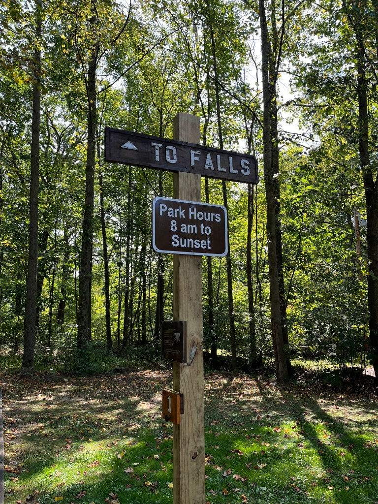
On the last Saturday in July, I loaded up the Jeep and headed up the mountain to Bilger’s Rock in Clearfield County. My Mom and sister were tagging along to enjoy a picnic and explore the outcrop with Centred Outdoors. According to some of my Clearfield County friends, visiting Bilger’s Rock is a local rite of passage. For me, living just over an hour away, I hadn’t had an opportunity to visit the rock city.

The night before, I checked my trusty 1990 copy of Roadside Geology of Pennsylvania for any information it could provide to geologically prepare myself for the visit. The entry for Bilger’s Rock was brief- “This rock city developed in highly cross-bedded sandstones of the Pottsville group. The sandstone is a single bed 20-25 ft. thick, broken along widely separated joints” (Van Diver, 1990).

I also read about Bilger’s Rock in Pennsylvania Caves & Other Rocky Roadside Wonders. The author, Kevin Patrick, had much more to say, covering a rough outline of the development of Bilger’s Rock. Initially deposited at least 300 million years ago, the outcrop was eventually exposed to the elements. The large “streets” are from frost wedging, specifically from a periglacial climate which has long since passed.

In more recent human history, the property on which Bilger’s Rock is located was once owned by homesteader Jacob Bilger. The acreage was later purchased in a sheriff sale by a company that quarried and mined in Clearfield County. Miraculously, Bilger’s Rock was left alone and became a local tourist spot, its popularity waning until the 1980s, when it was purchased by the Bilger’s Rock Association and lovingly transformed into a park.  

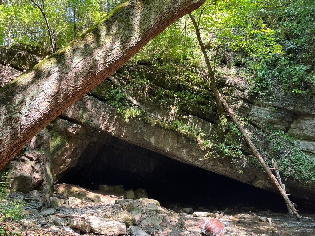
After our arrival and family picnic, our guide led us down a gravel path, descending from the top of the rocks into the city below. We passed by the Rock House; a facsimile of the shelter Roland Welker made in Alone season 7. Despite its small appearance, the Rock House was large inside… no wonder he became the 100 Day King!

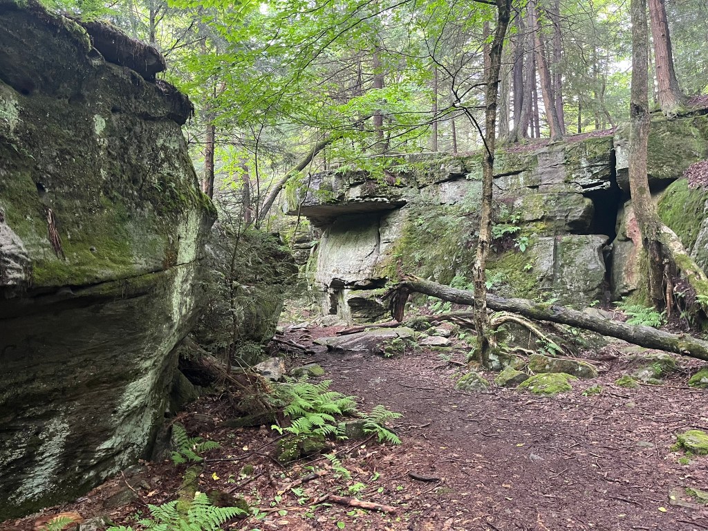
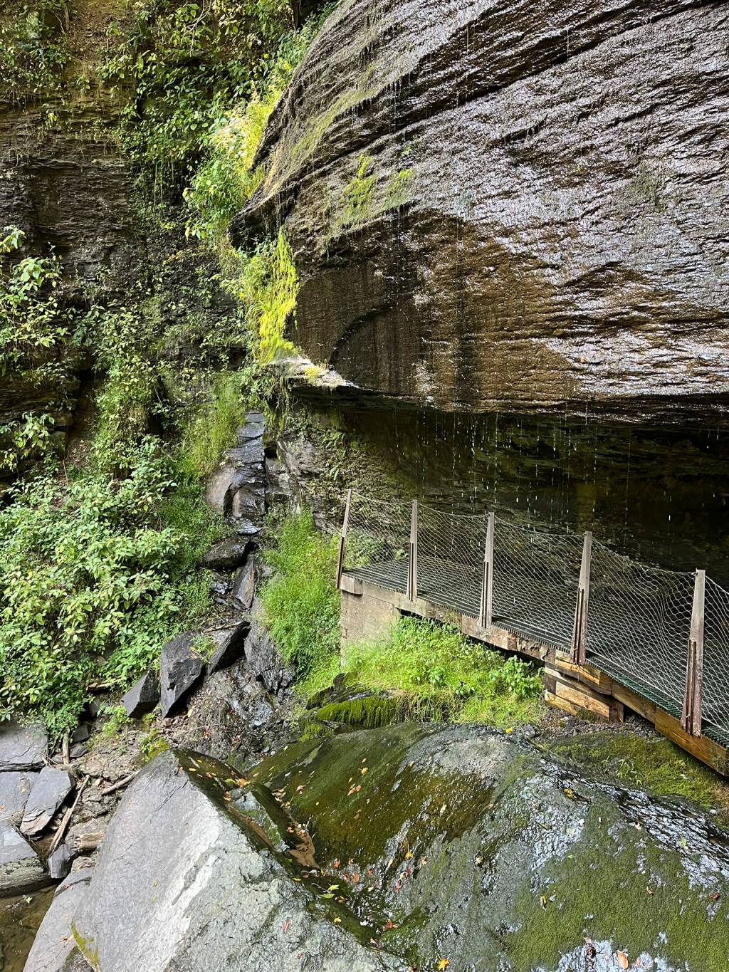
When the rocks came into view, I was speechless. Bilger’s Rock has a presence– something that words and pictures can’t capture. The 25-foot-tall walls towered over our heads, dark and glossy with a recent rain. Mosses and ferns draped over the rocks and trees sprouted in nooks too small for children. Our guide presented us with different opportunities to traverse the rocks, either ducking down to crawl under passes, or climbing up and over to the next spot.

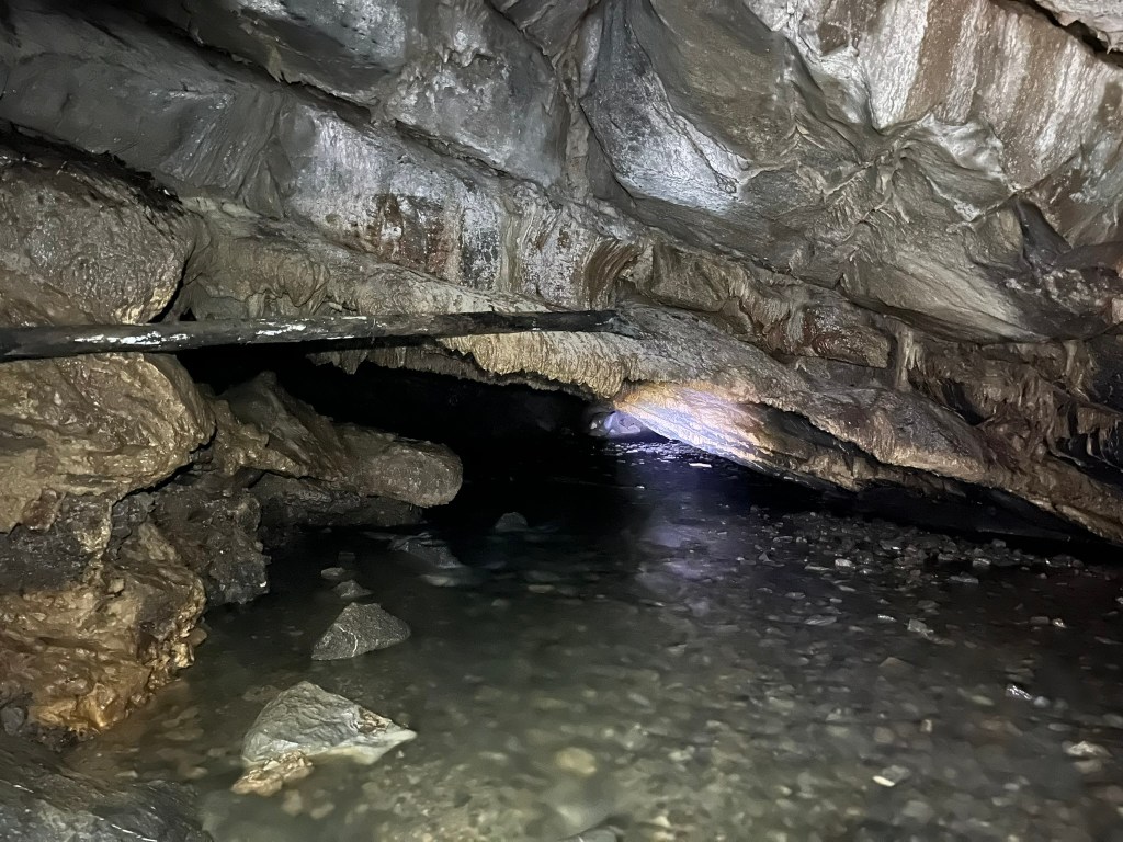
Time didn’t feel real while we were exploring Bilger’s Rock. The hour and a half we had with our guide zipped by. During that time, we explored the Devil’s Dining Room as a large group and broke off into smaller pairs to slip into the Devil’s Kitchen or Ice Cave. Eventually, we emerged at the “entrance” to Bilger’s Rock, the site of a large carving.

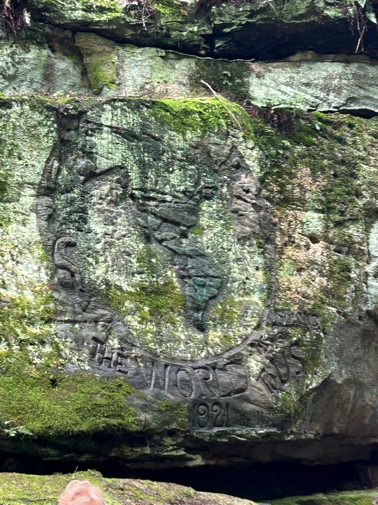
The rock art, “The World is Looking to Us” was completed by John W. Larson in 1921. Thought to be inspired by the U.S.’s role in World War I, it is now over 100 years old and showing signs of age. We took our time to look at the carving, and I thought about how even now, the world is looking to us… people that love the Earth and care for each other. In the moment, I felt very fortunate to be surrounded by a group of people that felt equally as curious and delighted by nature as me. For the remaining walk back to the top of the rocks, I dwelled on how I could help others feel the same.

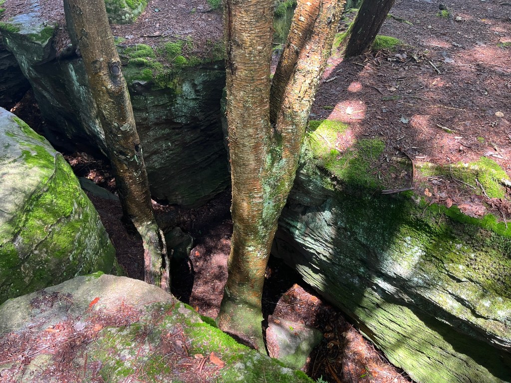
Meeting the rest of the group at the top of the rock city, we carefully walked around the cracks and joints, exploring its mossy roof. I now thought about the ancient seas that deposited the original sediments. At the time, a jungle of spectacular plants dominated the land above, and new, bony fish swam in the seas below. Pennsylvania was covered by shallow seas which rose and receded to create Bilger’s Rock… and the plethora of coal beds which were mined as Jacob Bilger bought the property in the 19th century.

Once our guided tour was over, our group gathered for the weekly Sock Sunday giveaway- which my sister won! With her prize in hand, and my gear safely stowed, we loaded back up in the Jeep for the long ride home. While we were a little muddy from clambering on the rocks, we were energized by our time in the cool microclimate down inside. All the way home we talked about the different little things we noticed… and made plans for returning with our full family sometime in the future.

Indiana County’s Buttermilk Falls

Usually the drive home from Pittsburgh area is uneventful- easy miles on Rt. 22 punctuated by Sheetz and upland forests. After 30 minutes on the road headed home, we decided to take a minor detour to Buttermilk Falls Natural Area.

A few miles down a country road, we pulled up to a gate staffed by a security guard. He provided simple directions: McFeely Trail to our right, and the Falls Trail to our left. After parking in the overflow section, we stretched our legs and headed to the trail on our left.

Crisp 65° air filtered through the trees while we meandered down the trail. We admired the accessibility of the walkway as it gracefully turned down the valley. Plenty of signs warned visitors to not stray off the trail- delicate plants grew near the Falls. I noticed plenty of common jewelweed, a sign that deer avoid the area.

We neared the first viewing platform in short order. Stepping out to the wooden deck, I couldn’t see any running water through the trees and brush. Straining my ears over the sounds of other hikers, I couldn’t hear a waterfall at all.

Past the first viewing platform, the trail continued over the crest of the falls to a second viewing area. Stairs descended the far side of the valley and led to a platform under Buttermilk Falls. Once we were on the Eclipse Bridge, I realized that Hires Run was very low. Water still descended the valley, but it was a gentle trickle than the roar I was hoping for.

Other hikers passed us as I led my partner down the stairs. Late summer wildflowers leaned over the cliffside; wood asters full of bumble bees. As we neared Buttermilk Falls, the scent of cool, wet rock permeated the air. As I waited for hikers to clear the area, I watched two small fish dart in the water pooling at the falls’ base.

We were soon able to walk behind Buttermilk Falls. A thick block of sandstone between two layers of shale allowed for an overhang to develop. Unfortunately, graffiti covered some of the shale wall behind the Falls. I wondered why visitors would want to deface natural beauty with grotesque images. As if to spite the graffiti, moss was spreading over the rock.

After snapping a few pictures, we started climbing back up the stairs to take a look at the rubble by the falls’ crest. From 1930 to 1956, Mr. Roger’s grandfather owned property along Hires Run, which Mr. Rogers visited as a boy. The foundation of the home, and the weirs used to dam Hires Run are still there. As children were exploring the area, I didn’t dare disturb the rocks to look for salamanders.

Walking back up the trail, we took our time to talk about football and decide that we will have to stop again. I want to visit in spring, when Hires Run is high and wildflowers are in bloom. My partner would like to visit when the Fall colors riot through the valley in mid-October. At any time, Buttermilk Falls are beautiful, and worth preserving. I’m thankful Indiana County Parks cares for this area and encourages visitors to do the same.

Works Cited

Indiana County Parks & Trails. “Buttermilk Falls.” Indiana County Parks & Trails, 26 Feb. 2024, www.indianacountyparks.org/our-parks/buttermilk-falls/. Accessed 9 Sept. 2024.

Caving Tytoona Cave Nature Preserve

In August, I revisited a favorite place: Tytoona Cave Nature Preserve. This was my 3rd time visiting. Tytoona continues to ignite excitement and curiosity in my heart!

Before You Continue

Caving is a dangerous activity. Dying while caving is 100% possible, no matter how “safe” you believe you are. To explore Tytoona, you need a permit from the National Speleological Society (NSS). You will agree to the Preserve’s Access Rules. More details are on the NSS website at: https://caves.org/preserve/tytoona-cave-nature-preserve/.

Karst Geology

Caves form underground when water dissolves soluble rock. A “soluble rock” is a rock that dissolves in water: limestone, dolomite, marble, and salt. Limestone and dolomite are sedimentary rocks which form via lithification of carbonate sediment. Marble is metamorphic, forming from limestone or dolomite after metamorphic stress.

Water dissolves rocks and forms specific phenomena labeled as karst. Sinkholes, disappearing streams, springs, and caves are examples of karst. Sinking Valley in Centre County is a good example of karst topography. The landscape is full of rolling hills and streams that seem to “disappear” or “sink” into the ground. Scattered throughout the valley are sinkholes and a handful of caves.

One stream, Sinking Run, formed a cave system- Tytoona. From its headwaters near Fort Roberdeau, Sinking Run “disappeared” into the ground. Water percolated through bedrock, dissolving limestone to form caverns. In one location, the water weakened the rock to cause the roof of a cavern to collapse, creating an entrance.

Inside Tytoona

Throughout Tytoona, speleothems are small. Formations like stalagmites, stalactites, draperies, and straws are often swept off by floodwaters. Some flowstones are visible along higher shelves in the cave. During my last visit, I struggled to take pictures of the formations close by.

Visitors must be mindful of the water- it is easy to slip and fall. Some areas of water are very deep. The area I was exploring had dry walkways, with Sinking Run ankle-deep to my right. When Sinking Run is high or fast, it’s too dangerous to enter the cave.

True History

Speleologists theorize that Tytoona connects to Arch Springs through a series of sumps. These underwater passages are difficult to explore and map. When I was younger, I had the opportunity to explore all the way to the back of the permit area. My instructor sat the class on gravel and told us the story of Roberta Swicegood, who lost her life in Tytoona.

In the late 1980s, Roberta was an experienced and passionate cave diver. She and John Schwein were surveying Tytoona. As a team, they were solo diving a series of sumps in zero-visibility waters. During their dives, the team was installing guide lines to help navigate in the darkness. On her last dive, Roberta left John behind and forged ahead into the unknown.

While surveying the sump, Roberta separated from the guide line. Speculation believes she ran out of air while searching for the line. Eventually, she fell asleep and then suffocated, alone in the darkness. After four days of recovery work, rescuers returned her body to the surface. She was found about 10 feet away from the guide line. If she had been able to reach the line, she could have survived and returned on her own.

After Roberta’s death, the property owners forbade diving and enacted a permit program. NSS is serious about enforcement, visitors are not to enter without a permit. Since Roberta’s passing, there have been no deaths in Tytoona.

Concluding Thoughts

Despite the danger, exploring a wild cave is a marvelous experience. With enough time, water creates beautiful and complicated features underneath our feet. While I have visited many times already, I know there are always more Tytoona trips for me in the future!

Works Cited

Czmor, Garrett. Tytoona Cave Preserve. Mid-Appalachian Region of the National Speleological Society, Dec. 2000, www.mar.caves.org/tytoona.htm. Accessed 6 Sept. 2024.

“Inside Cave, a Deadly Mystery.” Altoona Mirror, Altoona Mirror, 26 June 1988, www.newspapers.com/article/altoona-mirror-schweyen-cave-diving-dea/4043745/. Accessed 6 Sept. 2024.

Kevin Patrick. Pennsylvania Caves & Other Rocky Roadside Wonders. 1st ed., Stackpole Books, 2004, pp. 57–59.

“Tytoona Cave Nature Preserve.” National Speleological Society, 30 May 2024, www.caves.org/preserve/tytoona-cave-nature-preserve/. Accessed 6 Sept. 2024.